Kishtwar Plateau: A Study of its Geological and Historical Heritage
The Kishtwar Plateau, nestled in the heart of the Himalayas, presents a fascinating geological and cultural landscape shaped over millions of years by dynamic natural forces and human history. Unlike the sharply jagged peaks typical of the region, this plateau stands out as a unique elevated landform, whose origin intertwines scientific geological processes with rich local legends. Ancient tales speak of the vast Govardansar Lake, formed by floodwaters and later drained by seismic events or sage Kashyap’s intervention, creating the plateau’s early fertile grounds. Today, the Kishtwar Plateau offers a living testament to nature’s power and human resilience, where tectonic activity, glaciation, and hydrological shifts have collaborated to carve a distinctive terrain supporting some of the region’s oldest known human settlements.
The formation of the Kishtwar Plateau is an intriguing tale interwoven with legend, geological processes, and historical transformation spanning millions of years. Situated in the heart of the Himalayas, Kishtwar’s unique terrain and plateau-like formation distinguish it from the surrounding mountainous landscape, revealing a complex natural history shaped by powerful natural forces. Local history books and oral traditions recount that Kishtwar Plateau was once submerged beneath a vast, expansive lake known as Govardansar. This legendary lake stretched from the area presently known as Bhandarkoot to Shalimar, with the land beneath maintaining a relatively uniform elevation sloping gently southward. The natural topography during this ancient era created a water body that lent Kishtwar its distinctive early landscape. According to one popular legend, this lake formed when the floodwaters of the Mourye Soudar (now Warwan River) and the Chenab River, originating from the Paddar region, burst their banks, inundating the area from Singpora to Thathri. This flood was linked with the seismic activity common to the earthquake-prone Himalayan region. A massive earthquake reportedly struck, causing Thathri Mountain to burst open and drain the lake waters artificially, enabling the land to emerge from beneath the flood. An alternate mythological account attributes the lake’s drainage to the intervention of Kashyap Rishi, a revered sage. Accompanied by his three disciples namely Nand, Koul, and Jatta he is said to have created an outlet channel to release the water, thereby rescuing the inhabitants who had been struggling within this submerged landscape. The region was then called Kashapvas in his honor, marking early human interaction with natural changes in the region’s geography.
Geological Evidence:
Formation over Millions of Years contrasting and supporting the local legends, geological studies provide empirical insight into the Kishtwar Plateau’s formation. Unlike the jagged peaks typical of the Himalayas, the Kishtwar town’s geography resembles a plateau or, as described metaphorically, the back of a whale. This plateau represents a segment of mountain terrain that, over millions of years, underwent transformation through weathering and erosional processes. Originally, the mountains east and west of the current plateau were linked, with the landscape not resembling the plateau shape we see today. Over millennia, weathering processes softened the mountain slopes into a flattened, semi-planar plateau. Geological surveys reveal that the plateau’s current surface sits approximately 40 to 45 meters above the ancient land surface level, showing significant uplift. During the Pleistocene glaciation period, glaciers and avalanches dammed the Chenab River flowing through this region. Recurring flash floods and sediment deposits led to the formation of a vast lake on the plateau, blocked for possibly thousands of years. This prolonged presence of water left behind thick silty lacustrine deposits still visible in the region. Active tectonic uplift specifically along the Hasti-Pochhal fault has raised these lacustrine sediments up to 400 meters above the riverbed, creating the present-day plateau elevation. This region’s tectonics remains very active, with earthquake-prone faults causing vertical displacement and shaping the land. The Kishtwar Fault, a known left-lateral strike-slip fault, and the Main Central Thrust have contributed to the uplift and movement of rock formations, exposing crystalline complexes and sedimentary layers that define the plateau’s geological character.
Hydrological and Terrain Changes: Ancient Rivers and Shifting Lakes
As the damming from glacial activity faded with climate change and the melting of ice, water from the temporary lake began draining through newly formed channels. This process shaped the existing river routes: the Mourye Soudar flows southward on the plateau’s west side, while the Chenab River originally flowed through the plateau center before converging with Mourye Soudar near Hasti. Natural disasters, possibly including an earthquake, caused a sudden shift the mountain debris pushed lake water westward, carving new channels from Chambran to Pochhal. Traces of these ancient watercourses remain visible in the form of elevated channels and boulder marks, marking the water’s historical routes. Some residual water bodies persisted on the plateau even after most had drained, forming fresh water lakes such as Govardansar and Chougan, small remnants of the ancient lake. During recent infrastructure projects like the Dul-Hasti tunnel construction near Shalimar, engineers encountered unexpected water and soft clay instead of solid rock, providing direct physical evidence of the areas past lacustrine environment.
Catastrophic Events and Their Impact on Human Settlements
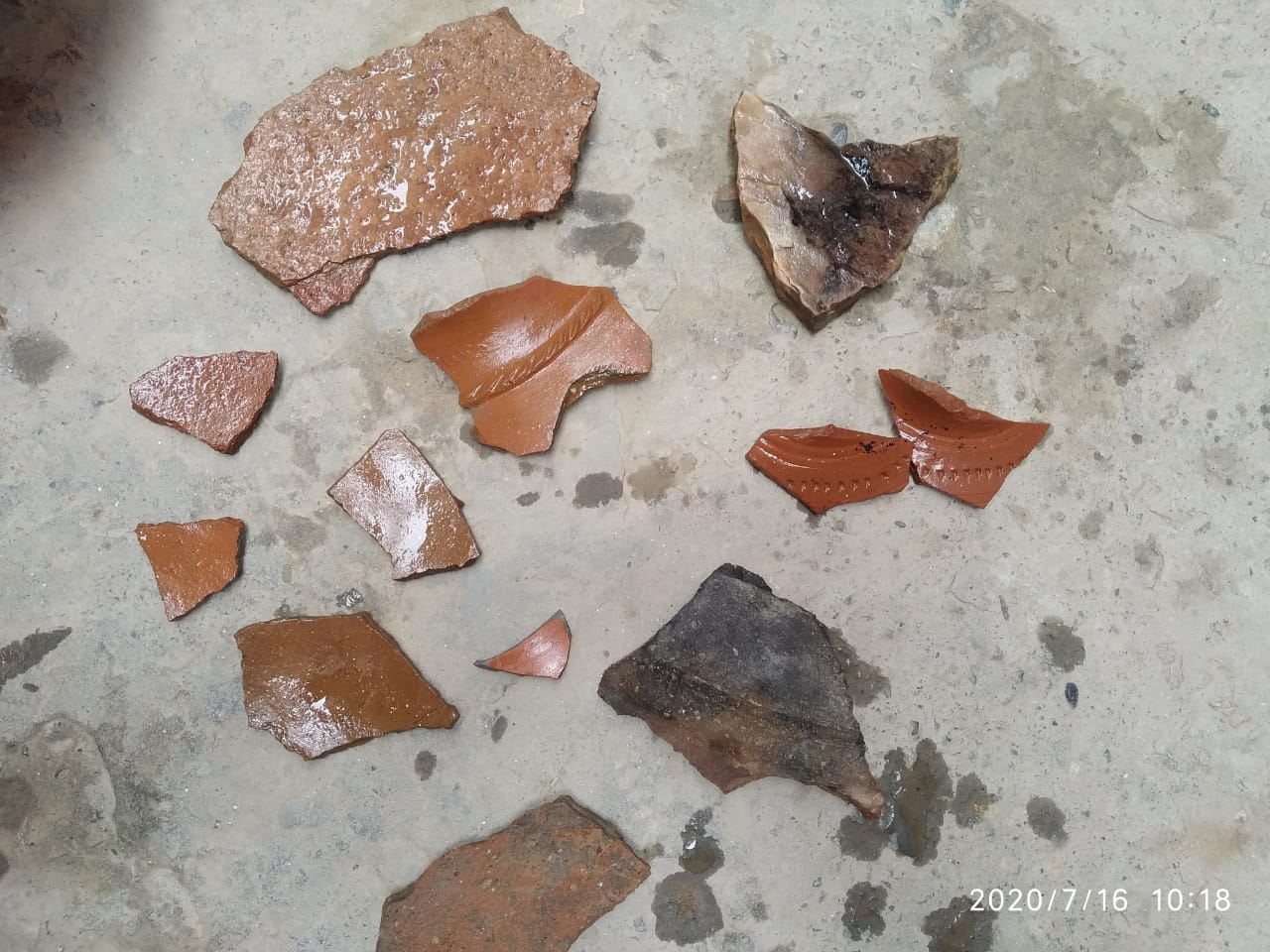
Historical geological processes did not only shape the landscape but also influenced human habitation and settlement patterns. Following the recession of the lake, the fertile soil on the plateau supported the growth of vegetation and eventually human populations. Early settlers flourished in areas like Phoie, Banderna, Huller, Wasser, and Kuleed. However, one tragic tectonic event struck the north-east mountain adjacent to the plateau (near Kuleed-Indranagar), causing a massive mountain fall. This regional landslide buried entire populations under rubble from the mountain debris, spanning from Sangrambhatta to Bun Astan, and filled previously deep river channels with sediment up to 40–50 feet thick. The soil layers and artifacts such as pottery found subsurface in these regions provide archaeological clues of the ancient calamity and earlier flourishing communities. One prominent archaeological discovery in the area was a Shivalinga, indicating the presence of Hindu cultural and religious activity predating the catastrophe. A temple constructed around this artefact further attests to the region’s historic habitation and cultural significance.
The Kishtwar Plateau exemplifies the intricate interplay of tectonics, climate, and hydrology in shaping mountainous terrain. Its geology features Proterozoic metamorphic complexes, sedimentary deposits, and active fault lines that reflect a dynamic earth history. The plateau’s uplift and lacustrine sedimentation underscore the role of glacial and tectonic forces in its evolution. This plateau serves as a natural laboratory for understanding Himalayan tectonics, river dynamics, and climatic impacts over geological timescales. The interplay between earthquakes, river damming, lake formation, and gradual drainage has left a lasting imprint, reflected in the landforms and deposits studied by geologists today.
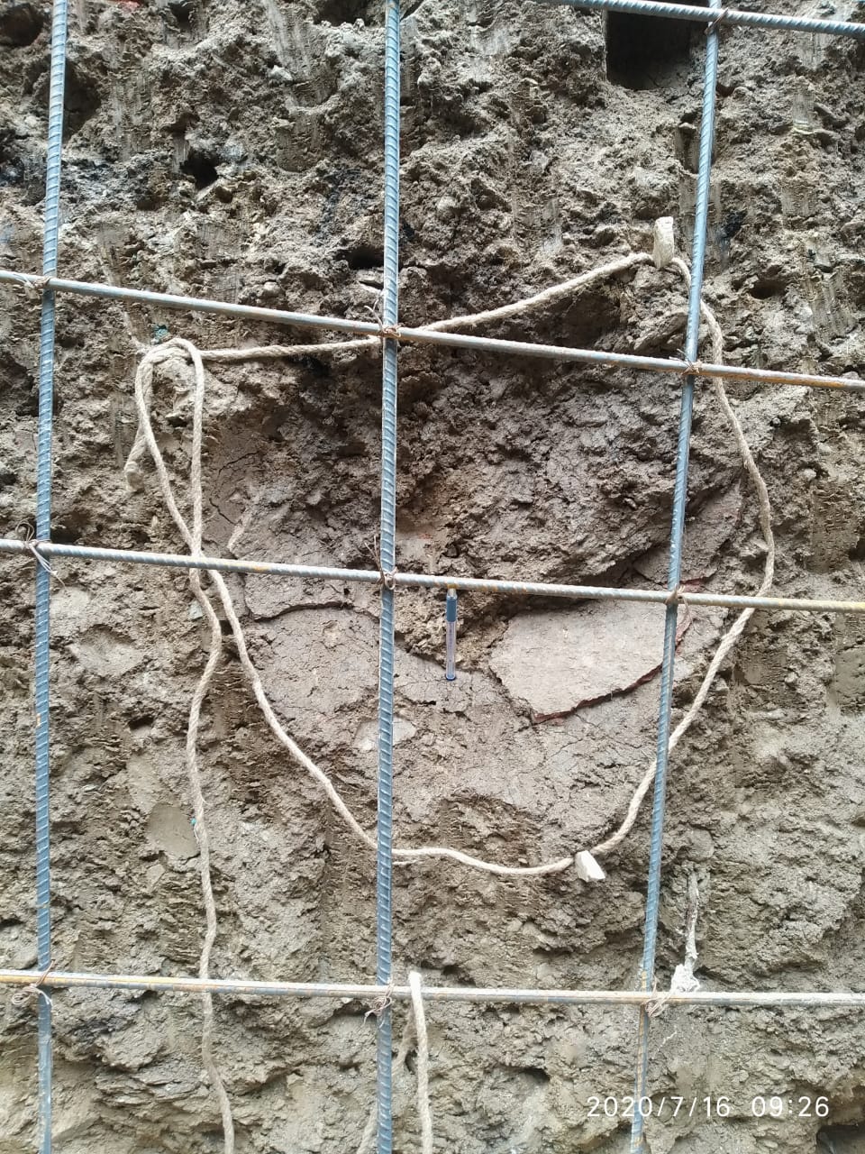
Bun Kuleed, a village in Kishtwar, is one of the oldest known human settlements. Excavations conducted five to ten feet below the present level have uncovered numerous ancient relics. These findings include utensils made of baked mud, fragments of baked pottery, ash, coal, burnt wood, and stones that appear to have been used as a stove. During pit digging in the village, a nozzle was discovered underground, suggesting the presence of an ancient Baolie or water reservoir. When excavated, the nozzle was facing north. Excavations within a hundred-meter radius of the ancient Shiva Mandir have consistently yielded artifacts, indicating a significant population in the area at some point in time. The residents of Bun Kuleed recounted finding a plinth with a hearth and a large circular stone while constructing his house. The plinth was located five to six feet below the present level, and he also discovered broken utensils, ash, and coal. Unfortunately, similar findings were destroyed during the construction of the TRC Kishtwar due to lack of awareness.
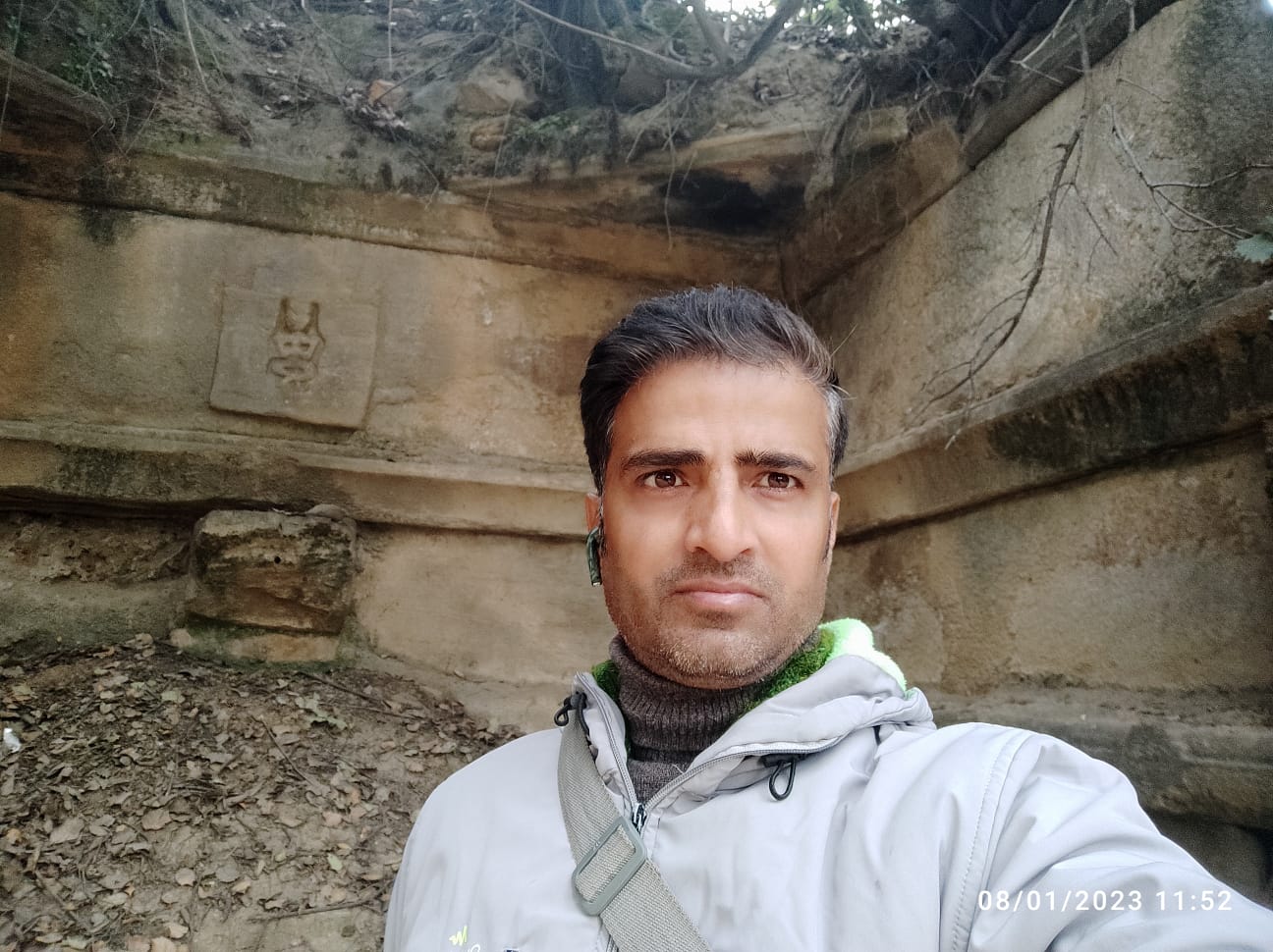
Deep within the rustic landscape, village Bun Kuleed lays a treasure unearthed by time: an ancient Shivalinga meticulously excavated from the earth. This revered relic, borne from the depths of antiquity, stands testament to the regions rich cultural heritage. Adorned with the gentle patina of age, the Shivalinga radiates an aura of serenity, inviting devotees to bask in its scared presence. The ancient Aap Swayambhu Shiv Mandir of Bun Kuleed Kishtwar is situated at the coordinates 33°19’32” N 75°45’34” E.
There are likely many more Archaeological sites in villages like Zellena, Wasser, Kuleed, Panditgam, and Indranagar that remained undiscovered. This is primarily due to widespread lack of awareness and recognition among local habitants about the value and existence of these archaeological sites. Additionally, challenges such as limited community involvement, insufficient promotion, and lack of proper management contribution to the difficulty in identifying and preserving these sites. Raising public awareness and involving stakeholders actively could help uncover and conserve these hidden historical treasures for future generations. Without such efforts, many valuable sites risk being neglected or lost.
Conclusion
The geological tale of the Kishtwar Plateau is a remarkable example of how earth’s tectonic vitality shapes human and ecological landscapes through eons. Its formation through glacial damming, lacustrine sedimentation, and tectonic uplift coupled with the enduring cultural imprint of ancient communities reflects the complex interplay between nature and civilization. Archaeological discoveries, such as the ancient Shivalinga and remnants of early habitation at Bun Kuleed, anchor the region’s historical significance within this changing environment. As a natural laboratory for understanding Himalayan tectonics and river dynamics, the Kishtwar Plateau continues to reveal the profound influences of earthquakes, river shifts, and human adaptation, underscoring the intricate bond between land and life in the Himalayas.
References:
- Sharma D.C. (1995), “History and Culture of Kishtwar” in English, Chandra Bhaga Publishers.
- Singh, R. (2007). Geology of Kishtwar Region, Jammu & Kashmir Himalaya. Journal of Geological Society of India, 69(4), 699–709.
- 2018 Study: Evidence of Active Tectonic Deformation in Kishtwar Area, Journal of the Geological Society of India.
- Central Ground Water Board aquifer mapping report on Kishtwar Plateau area detailing geological formations and fault structures.
Anil Kumar Bhagat (M.A. History, M.A. Sociology, B.Ed., I.T. & E.S.M.)
(Teacher in Education Department of U.T. J&K)
(Freelancer, Ancient Indian History, Culture and Archaeology)
Email: anilk11111982@gmail.com
Disclaimer:This article presents the author’s personal research and interpretation of historical events. www.mykishtwar.com provides this platform for the dissemination of information and diverse perspectives. The accuracy, completeness, and validity of any statements made within this article are solely the responsibility of the author. The content of this article is the sole responsibility of the author. www.mykishtwar.com does not assume any liability for the information presented. The author’s views and opinions do not necessarily represent those of www.mykishtwar.com. Readers are encouraged to conduct their own research and verify the information presented.