From Jammu
From Srinagar
Road Journey
244
Main Highway
Most Dangerous Road
The journey to Kishtwar is itself an experience — winding along the banks of the Chenab river, through the pine forests of Patnitop, past hairpin bends and dramatic gorges. The road is maintained by the Border Roads Organisation (BRO), and every kilometre brings a new view worth remembering.
Getting to Kishtwar — The Basics
District Headquarters Kishtwar is located approximately 235 km from Jammu and about 280 km from Srinagar. The main approach to the entire district is by road — taxi, Sumo, private buses, or state-run JKSRTC buses. There is no direct railway station or airport at Kishtwar; visitors fly or take the train to Jammu, and then proceed by road.
Two national highways connect the district to the rest of the country: NH 244 (formerly NH-1B) and NH 44 (formerly NH-1A). The breathtaking journey along the Chenab riverbank from Batote to Kishtwar is one of the most scenic drives in Jammu & Kashmir.
📍 Kishtwar — Distance from Major Cities
Srinagar — 280 km
Udhampur — 170 km
Doda — 60 km
Delhi — ~740 km
Chandigarh — ~540 km
Patnitop — ~130 km
Anantnag — ~83 km (via Sinthan)
🚌 By Road — From Jammu (Main Route)
The main hub to reach Kishtwar is Jammu city. From Jammu, Deluxe Buses are operated by both private agencies and JKSRTC (J&K State Road Transport Corporation). The journey takes approximately 5–6 hours by bus or 3–4 hours by private taxi/Sumo. You can also take a Sumo or shared taxi from Jammu’s GMC Chowk bus stand or from Udhampur.
🛣️ What You’ll See En Route — Jammu to Kishtwar
Udhampur — rail terminus, historic town · Kud — famous for sweets & dhabas
Patnitop — hill resort at 2,024m, stunning views · Ramgarh tourist bungalow
Batote — junction town where NH-1B branches off · good food stops
Thatri, Drabhsalla, Hasti — scenic villages along the Chenab gorge
Chenab River views — from Batote onwards, the majestic river accompanies you all the way into Kishtwar. Don’t forget: try Rajma Chawal with pure desi ghee at local dhabas!
🚌 JKSRTC Bus
Regular JKSRTC buses from Jammu (GMC Chowk Bus Stand) to Kishtwar. Fare approx. ₹200–250 per seat. Journey time 6–7 hours. jksrtc.nic.in
🚐 Private Bus / Deluxe
Several private agencies operate Deluxe Buses. Fare approx. ₹250–350 per seat. More comfortable, similar journey time to JKSRTC.
🚕 Taxi / Sumo
Private taxis and shared Sumos available from Jammu, Udhampur, and Ramban. Fastest option — approx. 3–4 hours by private taxi. Cost: ₹2,000–3,500 for full cab.
🚆 By Train — Nearest Railway Stations
Kishtwar does not have its own railway station. The nearest major railheads are:
✈️ By Air — Nearest Airports
Kishtwar is served by its own helipad/airstrip at the Chowgan, used by helicopters and light aircraft — a critical winter lifeline when NH 244 is blocked by snow. The nearest commercial airports are:
🛫 Jammu Airport (Satwari)
~235 km from Kishtwar. Daily flights from Delhi (~1.5 hrs, ₹2,500–₹6,000 one-way). Prepaid taxis and Ola/Uber at airport. Best overall option for most travellers.
🛫 Srinagar Airport
~280 km from Kishtwar. Option if travelling via Sinthan Pass (open April–October). Well connected to Delhi, Mumbai, Bengaluru. Taxi to Kishtwar via Anantnag–Sinthan–Kishtwar route.
🚁 Kishtwar Helipad (Chowgan)
Used for government and emergency helicopter services. AAI is contemplating developing a full airport here — a development that will transform connectivity for the district.
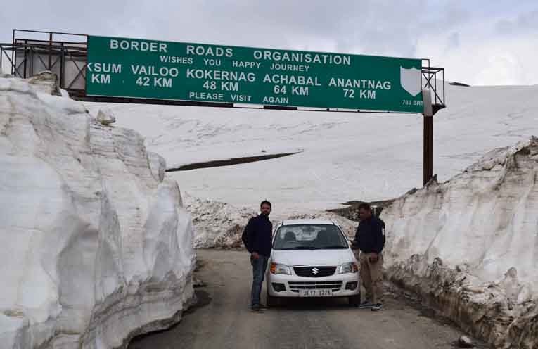
🏔️ Via Sinthan Pass — Kishtwar to Srinagar (83 km)
The Sinthan Pass route (NH 244) connects Kishtwar to Srinagar via Anantnag in just 83 km — far shorter than the Jammu route — and is open from approximately April to October. The pass sits at 12,500 feet (3,800 m) and offers one of the most breathtaking drives in India.
Along the Sinthan route from Srinagar, you can also visit Kokernag, Achabal, Daksum, and Verinag (origin of the Jhelum river) — making it one of the most rewarding multi-destination drives in J&K. Natural springs along the pass carry the purest, most digestible water in the Himalayas — a proposal was even mooted to bottle and export this water nationally.
🗺️ Sinthan Route — Stops & Distances
→
Anantnag
→
Kokernag
→
Daksum
→
🏔️ Sinthan Top (3,784m)
→
Sinthan Maidan
→
Chatroo
→
🏙️ Kishtwar
⚠️ Via Himachal Pradesh — The Cliffhanger Road (160 km)
For the truly adventurous, there is the route via Paddar to Killar (Himachal Pradesh) — a distance of approximately 160 km and one of the world’s most extreme mountain roads. The Kishtwar–Killar road, also known as the ‘Cliffhanger’ or ‘Almost Killer Road’, is widely cited as India’s 9th most dangerous road.
⚠️ Cliffhanger Road — What to Expect
Road is winding and in some places wide enough for only one vehicle at a time
One side: sheer cliff face · Other side: drops of hundreds of metres, unprotected by guardrails
Total distance Kishtwar to Killar (Himachal Pradesh): ~121 km · Daily bus available (limited frequency)
Shared taxis more frequent than buses — costs similar. Only for experienced mountain travellers. Words cannot describe it — pictures do not do it justice.
🗺️ Major Road Routes Within Kishtwar District
Kishtwar → Srinagar via Sinthan Pass
83 km · Open Apr–Oct · NH 244 · via Chatroo–Sinthan Maidan–Sinthan Top–Daksum–Anantnag
Kishtwar → Killar (Himachal Pradesh) via Paddar
160 km · The Cliffhanger · India’s 9th most dangerous road · via Ishtiyari & Sansari
Kishtwar → Ghan via Sarthal
Link road to Sarthal and beyond — serving religious and rural communities
Kishtwar → Bimal Nag via Drabhsalla
Internal link route connecting Drabhsalla and surrounding villages
Kishtwar → Mughal Maidan via Bhandarkoot
The Marwah road — gateway to Dachhan, Marwah, Warwan, Ikhala, and Kishtwar National Park
🍲 A Traveller’s Must — Rajma Chawal with Desi Ghee
Don’t miss the Rajma Chawal cooked with pure desi ghee at local dhabas between Batote and Kishtwar — a humble, hearty Pahadi meal that tastes like nowhere else in the world. This is what the mountains taste like.
💡 Did you know? During winter when the NH 244 gets blocked by snow and landslides, Kishtwar’s helipad at the Chowgan becomes the primary lifeline for emergency services and essential supplies. The Airport Authority of India (AAI) has been contemplating construction of a full airport at the Chowgan — a development that would transform Kishtwar’s accessibility year-round.
🗺️ The Road to Kishtwar is the Beginning of the Adventure 🏔️
Related Topics
Kishtwar Road Route
Jammu to Kishtwar Distance
Sinthan Pass Route
Cliffhanger Road Kishtwar
JKSRTC Bus Kishtwar
NH 244 Kishtwar
Kishtwar Airport Helipad
Kishtwar Killar Road
mykishtwar.com
Travel Guide Series |
mykishtwar.com
· Kishtwar, Jammu & Kashmir, India