“Where the Chenab roars through granite gorges and glaciers feed ancient streams — Tehsil Atholi is not merely a place on a map. It is the soul of Paddar, the Sapphire Valley of India.”
— MyKishtwar.com Editorial
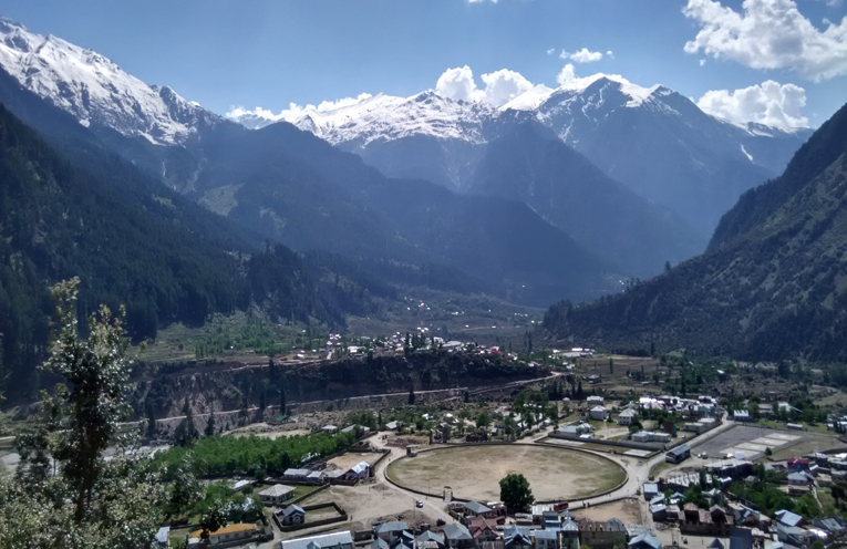
Tucked away in the rugged southeastern corner of Kishtwar district lies Tehsil Atholi (Paddar) — one of the most remote, pristine, and culturally vibrant sub-districts in the Union Territory of Jammu & Kashmir. Officially raised to Tehsil status in 2005 and formally approved as Atholi Tehsil on 6 July 2006, this high-altitude region is universally known as the heart of the Paddar Valley, and more famously as the Sapphire Valley of India.
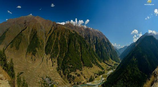
Draped in snow-capped peaks, dense conifer forests, glacial rivers, and ancient Himalayan settlements, Atholi sits at the confluence of nature, culture, spirituality, and mineral wealth. Whether you come as a trekker, a pilgrim, a geologist, or simply a traveller chasing untouched beauty — Paddar will leave an imprint that no other valley in Jammu & Kashmir quite replicates.
📍 Geographical Location & Boundaries
Tehsil Atholi, commonly referred to as Paddar Valley, occupies the northeastern reaches of District Kishtwar, forming the upper Chenab Valley corridor. It sits approximately 42 kilometres east of Kishtwar town at an average elevation of 1,938 metres (6,360 feet) above sea level — though several high-altitude areas within the tehsil rise well beyond 4,000 metres.
📌 Geo-Coordinates
🌐 Latitude: 33°09′20″N | Longitude: 76°05′34″E
🏔️ Highest Inhabited Village: Suncham — 3,385 m above sea level
The tehsil shares striking boundaries on all four sides:
- North & East: Zanskar region of Ladakh
- South: Pangi Valley, Himachal Pradesh
- West: Tehsil Nagseni (Bhalessa)
The traditional gateway into Paddar begins at Liddrari Nala, crossing the roaring Chanderbhaga (Chenab River) at a point that divides Chhichha from Sazar. The geographic and commercial heart of the tehsil is the scenic confluence of the Chenab and the Botnalla River — the latter affectionately called the “Buddhist Stream” by locals.
Tun is the remotest village of Paddar, located in Gandhari Nala along the Himachal Pradesh border, while Suncham — at 3,385 m — is the highest permanently inhabited settlement, serving as the gateway to Padam in Zanskar via the legendary Umasi La Pass (5,340 m).
An Ishtihari road is also earmarked to link Paddar with Pangi of Himachal Pradesh via Sansari, approximately 2 km from the village of Thumb in Ishtihari Pargana.
🏛️ Administrative Overview
Atholi serves as the administrative headquarters of the tehsil and is the principal seat of governance for the entire Paddar region. The tehsil handles:
- Revenue and land administration
- Rural development and MGNREGA implementation
- Education and healthcare services
- Agricultural and horticultural extension
- Local trade, transport, and commerce
📊 Tehsil-Level Population Summary (Census 2011)
| S.No. | Tehsil | Households | Total Population | Male | Female |
|---|---|---|---|---|---|
| 1 | Atholi (Paddar) | 3,900 | 19,734 | 10,341 | 9,393 |
🌤️ Weather & Climate
Tehsil Atholi experiences a high-altitude alpine-temperate climate, shaped by its proximity to mountain glaciers and the Great Himalayan range. The best season for tourism is June through September, when the valley turns a brilliant green under open skies.
| Season | Months | Avg. Temperature | Climate Profile |
|---|---|---|---|
| 🌸 Spring | April – May | 5°C – 18°C | Snow melts in lower areas; valleys turn green and vibrant. |
| ☀️ Summer | June – Sept | 15°C – 25°C | Peak season. Lush terraced fields, brilliant blue skies, ideal for trekking and pilgrimage. |
| 🍂 Autumn | Oct – Nov | 5°C – 15°C | Golden oak-tree landscapes; harvesting season; clear mountain panoramas. |
| ❄️ Winter | Dec – March | -5°C – 8°C | Heavy snowfall; upper villages often isolated; a pristine winter wonderland. |
💎 The World-Famous Paddar Sapphire Mines
Paddar is home to what are widely regarded as the finest sapphires in the world — celebrated for their extraordinary peacock-blue colour, unmatched durability, and natural clarity. The mines lie at altitudes approaching 16,000 feet near Sumchan and Bilakoth in the Machail sub-valley, guarded by a police post at Suncham village to deter smuggling.
In May 2004, a single Paddar sapphire was auctioned at Geneva for a staggering USD 1.5 million — putting this remote Himalayan valley on the world gemstone map. The estimated sapphire reserves of Paddar Valley are believed to be worth over ₹10,000 crore.
Despite this extraordinary wealth, the mines have historically been under-explored. Geological surveys have confirmed the presence of sapphires, rubies, and other precious stones in the greater Himalayan range along the Chenab basin. The Jammu & Kashmir government has in recent years initiated fresh exploration efforts — a development that carries the potential to transform the economic future of this long-neglected district.

💡 Did You Know?
The Paddar Sapphire is considered superior even to sapphires mined in Kashmir’s Zanskar and Sri Lanka’s Ceylon mines. Its vivid peacock-blue hue is caused by trace elements of iron and titanium in the corundum crystal — a geological gift from the Great Himalayan belt.
🏕️ Tourist Places & Local Landmarks
1. Gulabgarh Town — The Valley’s Base Camp
Gulabgarh (“Fort of Gulab”) is the twin-town of Atholi, situated just across the riverbank and serving as the primary market, transit hub, and institutional centre of Paddar. Named after Maharaja Gulab Singh, it was historically used by the legendary Dogra General Zorawar Singh as a frontier post for his famous trans-Himalayan military expeditions into Ladakh, Baltistan, and Tibet. Today it is the last motorable point on the road to Machail Mata shrine.
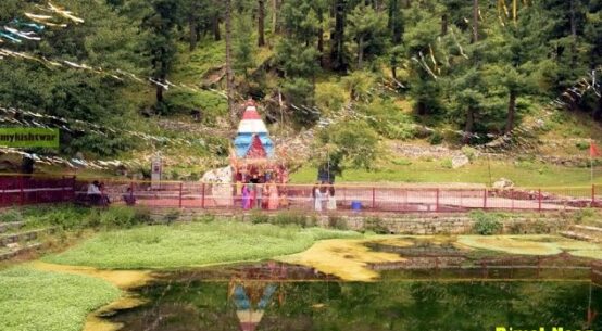
2. Machail Chandi Mata Temple & Annual Yatra
Located at an altitude of approximately 9,500 feet in the remote Machail village, the Machail Chandi Mata Temple is one of the most revered Hindu pilgrimages in the Jammu region. Dedicated to Goddess Durga (Chandi), the shrine draws over 50,000 pilgrims annually — making it the second-largest pilgrimage in Jammu division. In 2018, the yatra recorded over 1.5 lakh devotees. The annual Yatra begins in August, with the sacred Chhadi (Holy Mace) procession originating from Bhaderwah. From Gulabgarh, pilgrims trek a breathtaking 30 km through Paddar’s gorges and meadows to reach the shrine. Helicopter services from Kishtwar and Gulabgarh are also available for those who cannot trek.
3. Tatta Pani — Natural Sulphur Hot Springs
One of the most remarkable natural marvels in Tehsil Atholi, Tatta Pani is a cluster of natural sulphur hot springs where thermal waters continuously bubble into stone basins. Pilgrims and travellers from across the region journey here to bathe in the warm waters, which are widely recognised for providing therapeutic relief for joint pain, arthritis, and skin ailments. The springs make for a deeply restorative stop on any Paddar itinerary.
4. Umasi La Pass — Gateway to Zanskar
At a staggering 5,340 metres (17,520 feet), the Umasi La Pass connects Paddar to the ancient Buddhist kingdom of Padam in Zanskar, Ladakh. This high-altitude crossing — one of the most challenging and least-trodden trans-Himalayan routes — departs from Suncham village and draws expert mountaineers and adventure trekkers from around the world. The route passes through alpine meadows, glacial moraines, and some of the most raw wilderness in the Himalayan range.
5. Pathaal, Ghiraat & Mounda Meadows
Within Atholi village, Pathaal is a serene and scenic local spot beloved for evening walks. Nearby, visitors can observe the fascinating indigenous Ghiraat — traditional water mills powered entirely by the kinetic energy of cascading mountain waterfalls, used to grind local wheat and maize. Higher up, the Mounda Meadows offer lush alpine grasslands carpeted with wildflowers in summer, along with sweeping panoramic views of the surrounding snow-clad peaks.
6. Ancient Stone Carvings & Sacred Springs
Scattered along the footpaths and natural water springs of old Atholi settlements are ancient, weather-worn stone carvings of remarkable intricacy. Local folklore attributes these relics to the era of the Mahabharata, with oral traditions recounting the journey of the Pandavas through these very mountain passes. Paddar’s early history also records a rich Buddhist cultural influence between the 10th and 14th centuries, when the region formed part of the Guge Kingdom — traces of which survive in the local reverence for serpent deities and Nagdevta temples with intricate snake carvings.
🌾 Economy, Culture & Way of Life
The lifestyle of Tehsil Atholi preserves a deep-rooted alpine mountain tradition — a unique cultural hybrid drawing from Pangi (Himachal), Bhaderwah, and Ladakhi influences.
🌽
Agriculture
75–85% of the population depends on terrace farming. Key crops: maize, wheat, barley, rajma, potatoes, and seasonal vegetables, using smart inter-cropping to maximise the short summer window.
🍎
Horticulture
Apples, walnuts, apricots, and other temperate fruits flourish in the valley, adding an important cash income stream for local households.
🐑
Livestock & Wool
Sheep rearing, goat farming, and cattle rearing are central to livelihoods. Men expertly spin local wool to craft heavy trousers, traditional Kantop caps, and the legendary grass Pulhor shoes for snow travel.
🗣️
Languages
A rich linguistic blend is spoken across the tehsil: Paddri (native dialect), Pangwali, Kishtwari, Ladakhi, Dogri, Kashmiri, Hindi, and Urdu — reflecting centuries of cross-cultural exchange.
Atholi thrives as a peaceful multi-faith community where Hindus, Muslims, and Buddhists live side by side in warm coexistence — a microcosm of the pluralistic spirit that Kishtwar district is celebrated for across Jammu & Kashmir.
🚗 How to Reach Tehsil Atholi (Paddar)
| From | Distance | Route / Notes |
|---|---|---|
| Kishtwar Town | ~42–50 km | Motorable road along the Chenab River gorge. Regular bus and taxi services. |
| Jammu City | ~280 km | Via Batote (NH-244). Approx. 8–9 hours by road. |
| Nearest Airport | Jammu (~245 km) | Jammu Airport (IXJ), then road journey to Kishtwar and onward to Atholi. |
| Nearest Railhead | Udhampur (~166 km) | Udhampur or Jammu Tawi (240 km) railway stations. Taxi/bus onward. |
| Zanskar (Padam) | Via Umasi La | High-altitude trekking route (5,340 m). For expert mountaineers only. July–September. |
🏘️ Villages of Tehsil Atholi — Census 2011 Data
Tehsil Atholi comprises 27 revenue villages spread across the vast Paddar landscape. Below is the detailed demographic summary from Census 2011:
| # | Village | Households | Population | Male | Female | Literacy % | Sex Ratio |
|---|---|---|---|---|---|---|---|
| 1 | Afani | 225 | 1,184 | 621 | 563 | 57.70% | 907 |
| 2 | Atholi ★ | 256 | 1,214 | 610 | 604 | 76.40% | 990 |
| 3 | Batwas | 41 | 259 | 125 | 134 | 60.53% | 1,072 |
| 4 | Cheto | 146 | 684 | 365 | 319 | 51.47% | 874 |
| 5 | Chug | 31 | 222 | 114 | 108 | 63.48% | 947 |
| 6 | Garh (Padder) | 193 | 1,011 | 540 | 471 | 42.86% | 872 |
| 7 | Gulab Garh | 231 | 1,195 | 645 | 550 | 62.23% | 853 |
| 8 | Ishtahari | 254 | 1,412 | 771 | 641 | 51.28% | 831 |
| 9 | Jar | 97 | 381 | 205 | 176 | 38.29% | 859 |
| 10 | Kaban | 151 | 741 | 356 | 385 | 61.38% | 1,081 |
| 11 | Kadail | 99 | 489 | 244 | 245 | 57.49% | 1,004 |
| 12 | Kidru | 54 | 291 | 145 | 146 | 25.33% | 1,007 |
| 13 | Kundal | 276 | 1,422 | 732 | 690 | 64.15% | 943 |
| 14 | Layee | 45 | 218 | 114 | 104 | 58.85% | 912 |
| 15 | Leoundi | 103 | 535 | 285 | 250 | 52.05% | 877 |
| 16 | Ligri | 398 | 1,824 | 976 | 848 | 51.74% | 869 |
| 17 | Luder | 94 | 471 | 225 | 246 | 62.20% | 1,093 |
| 18 | Massu | 148 | 754 | 400 | 354 | 65.09% | 885 |
| 19 | Mati | 84 | 403 | 215 | 188 | 36.84% | 874 |
| 20 | Muthal | 42 | 251 | 127 | 124 | 58.10% | 976 |
| 21 | Ongayee | 126 | 623 | 335 | 288 | 50.56% | 860 |
| 22 | Palali | 251 | 1,429 | 746 | 683 | 58.59% | 916 |
| 23 | Pandail | 97 | 469 | 238 | 231 | 49.88% | 971 |
| 24 | Sazar | 102 | 478 | 265 | 213 | 45.45% | 804 |
| 25 | Sohal | 137 | 671 | 363 | 308 | 79.57% | 848 |
| 26 | Tun | 35 | 228 | 121 | 107 | 46.33% | 884 |
| 27 | Tyari | 184 | 875 | 458 | 417 | 50.07% | 910 |
| TOTAL (Tehsil Atholi) | 3,900 | 19,734 | 10,341 | 9,393 | — | — | |
★ Tehsil HQ | Source: Census of India 2011 | Green = above J&K avg literacy (67.16%) | Red = significantly below avg
📋 Village-wise Detailed Data — Tehsil Atholi
The table below presents the detailed schedule caste, schedule tribe, and worker data for each village in Tehsil Atholi (Paddar) as recorded in Census 2011:
| Village | Pop. | Children (0–6) | SC | ST | Total Workers | Main Workers | Marginal | Child SR |
|---|---|---|---|---|---|---|---|---|
| Afani | 1,184 | 217 | 0 | 18 | 318 | 318 | 0 | 824 |
| Atholi ★ | 1,214 | 176 | 70 | 0 | 330 | 329 | 1 | 934 |
| Batwas | 259 | 31 | 0 | 0 | 66 | 66 | 0 | 938 |
| Cheto | 684 | 107 | 42 | 0 | 364 | 362 | 2 | 877 |
| Chug | 222 | 44 | 33 | 0 | 54 | 50 | 4 | 913 |
| Garh (Padder) | 1,011 | 178 | 75 | 0 | 417 | 402 | 15 | 1,312 |
| Gulab Garh | 1,195 | 218 | 469 | 202 | 313 | 313 | 0 | 758 |
| Ishtahari | 1,412 | 238 | 93 | 0 | 449 | 413 | 36 | 889 |
| Jar | 381 | 65 | 0 | 0 | 119 | 118 | 1 | 757 |
| Kaban | 741 | 91 | 7 | 733 | 327 | 327 | 0 | 625 |
| Kadail | 489 | 75 | 0 | 46 | 131 | 130 | 1 | 1,027 |
| Kidru | 291 | 66 | 0 | 105 | 68 | 67 | 1 | 941 |
| Kundal | 1,422 | 164 | 196 | 0 | 388 | 369 | 19 | 783 |
| Layee | 218 | 26 | 43 | 0 | 67 | 67 | 0 | 1,000 |
| Leoundi | 535 | 97 | 0 | 0 | 157 | 157 | 0 | 764 |
| Ligri | 1,824 | 299 | 172 | 0 | 518 | 509 | 9 | 904 |
| Luder | 471 | 90 | 219 | 0 | 123 | 122 | 1 | 765 |
| Massu | 754 | 78 | 39 | 0 | 321 | 236 | 85 | 696 |
| Mati | 403 | 80 | 132 | 0 | 113 | 108 | 5 | 818 |
| Muthal | 251 | 41 | 0 | 0 | 58 | 57 | 1 | 952 |
| Ongayee | 623 | 87 | 41 | 0 | 192 | 144 | 48 | 891 |
| Palali | 1,429 | 241 | 172 | 0 | 534 | 526 | 8 | 1,133 |
| Pandail | 469 | 62 | 47 | 0 | 126 | 123 | 3 | 1,214 |
| Sazar | 478 | 71 | 68 | 0 | 122 | 121 | 1 | 775 |
| Sohal | 671 | 108 | 45 | 0 | 217 | 215 | 2 | 895 |
| Tun | 228 | 51 | 0 | 204 | 48 | 48 | 0 | 889 |
| Tyari | 875 | 136 | 60 | 0 | 214 | 214 | 0 | 1,030 |
Source: Census of India 2011. SR = Sex Ratio (females per 1,000 males). Child SR = Child Sex Ratio (0–6 age group).
🏔️ Why Tehsil Atholi (Paddar) Is Truly Special
Tehsil Atholi (Paddar) is truly the jewel of District Kishtwar — a land where majestic mountains, crystal-clear rivers, ancient cultures, sacred shrines, and precious blue gems come together in extraordinary Himalayan harmony. Its untouched beauty, high-altitude drama, and multi-layered heritage make it one of the most remarkable destinations in the entire Union Territory of Jammu & Kashmir.
Whether you come for the pilgrimage trails, the alpine meadows, the world-famous sapphires, or simply the warm hospitality of its mountain people — Paddar will hold you in its spell long after you have returned to the plains.
Related Topics
Sapphire Mines Kishtwar
Machail Mata Yatra
Umasi La Trek
Gulabgarh Paddar
Tatta Pani Hot Springs
Kishtwar Tourism
Chenab Valley J&K
Census 2011 Kishtwar
Himalayas Adventure
mykishtwar.com
Your definitive digital guide to the land of sapphires and saffron since 2011
📞 +91-7006607991 | ✉️ contact@mykishtwar.com | 📍 Kishtwar, Jammu & Kashmir
Mr. Pradip,
Hope you are well. It’s really a nice blog to know about Paddar region! I am Biswarup Halder from kolkata . We are planning to trek in Paddar region towards Bhut nala/Bhajung nala on May 2012. We are a team of 7 members. We will start our trek from Gulabgarh. We need 2 horses to carry our ration, tents etc. I heard about Dhyan Sing who is a ‘Ghora wala’ live in Gulabgarh & used to go in those routes. But I can’t contact him through his mobile number. Can you help me out & suggest how could I manage to get 2 horses on make contact with some Ghorawala!! It’s urgent. Please mail me on – biswaruph@gmail.com
My mobile number is – +919830810233
Can you provide any mobile number of anyone stay in Gulabgarh that can help us!!
Waiting for your reply.
Thank you,
Biswarup.
sorry for late reply
you can mail me on kishtwarjannat@gmail.com
I will try to help you in better way.
Waiting for you mail
Thanks Pardeep
hi pradeep , we guys r planning a road trip chandigarh to kishtwar , we r coming through spiti & lahual valley … but we r not sure about the road from udaipur to padder , it would be great help if u can update the status of this road ..
thanks
Navjot S Mann
i don’t about the road from HP valley, but as i hear this road is preety tough and u should use Mahindra Max /Tata Sumo instead of any other vehicle. But you will definitely enjoy the thrill of this road.
for more info, mail me on kishtwarjannat@gmail.com